The Cholistan desert is located in Bahawalpur, Rahim Yar Khan and Bahawalnagar Districts. The area consists of shifting sand dunes. The dunes reach height of about 100m in greater Cholistan.
It is also locally known as Rohi. Also a part of the Greater Thar Desert, which extends to Sindh province and the Indian state of Rajasthan. It is one of two large deserts in Punjab, the other being Thal Desert.
Overview On Cholistan Desert :
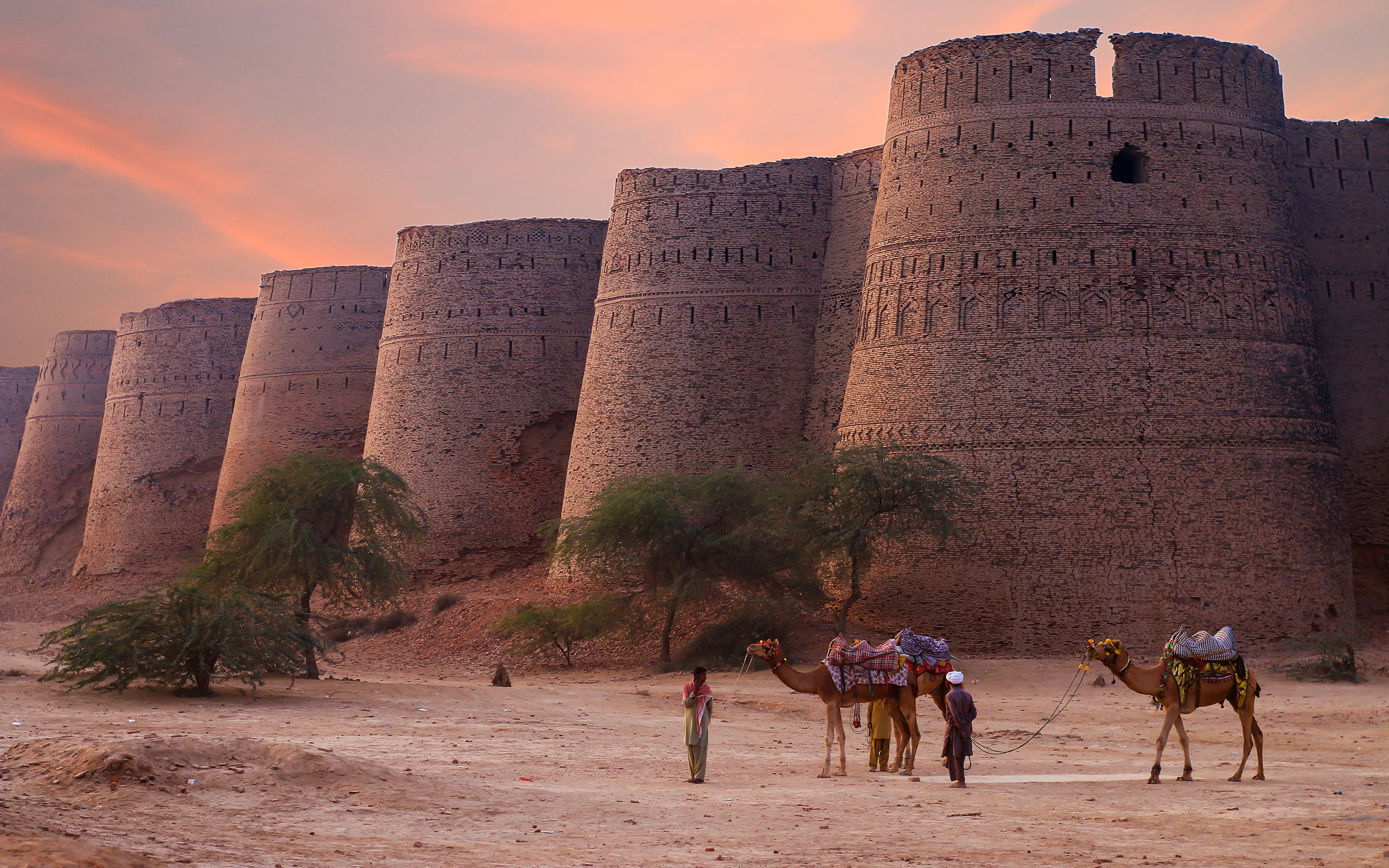
In ancient times, Cholistan was a fertile region with a large river fed by meltwater from the Himalayas, and so has a high density of ancient settlements from the Indus Valley civilization period dating back as early as 4000 BCE. The region later became a center for caravan trade, leading to the construction of numerous forts in the medieval period to protect trade routes – of which the Derawar Fort is the best example.
Furthermore Geologically, Cholistan is divide into the Greater Cholistan and Lesser Cholistan, which are roughly divide by the dry bed of the ancient Hakra River. Greater Cholistan is a mostly sandy area in the south and west part of the desert up to the border with India, and covers an area of 13,600 km2. Sand dunes in this area reach over 100 meters in height. Soil in the region is also highly saline. Lesser Cholistan is an arid and slightly less sandy region approximately 12,370 km2 in area which extends north and east from the old Hakra river bed, historically up to the banks of the Sutlej River.
Soil quality is generally poor with little organic matter in the Greater Cholistan, and compacted alluvial clays in the Lesser Cholistan. A canal system built during the British era led to irrigation of the northern part of Lesser Cholistan.
Geography :
Cholistan covers an area of 25,800 km2 in the Bahawalpur, Bahawalnagar, and Rahim Yar Khan districts of southern Punjab. The nearest major city is Bahawalpur city, 30 km from the edge of the desert. The desert stretches about 480 kilometres in length, with a width varying between 32 and 192 kilometres. It is located between 27°42΄00΄΄ to 29° 45΄00΄΄ north, and 69°57′ 30’′ to 72° 52′ 30’′ east. 81% of the desert is sandy, while 19% is characterize by alluvial flats and small sandy dunes. The entire region is subject to desertification due to poor vegetation cover resulting in wind erosion.
Climate Of Cholistan Desert :
Cholistan’s climate is characterize as an arid and semi-arid Tropical desert, with very low annual humidity. The mean temperature in Cholistan is 28.33 °C, with the hottest month being July with a mean temperature of 38.5 °C. Summer temperatures can surpass 46 °C, and sometimes rise over 50 °C during periods of drought. Winter temperatures occasionally dip to 0 °C. Average rainfall in Cholistan is up to 180mm, with July and August being the wettest months, although droughts are common. Water is collect seasonally in a system of natural pools known as Toba, or manmade pools call Kund. Subsoil water is locate at a depth of 30–40 meters, but is typically brackish, and unsuitable for most plant growth.
Historical View :
Though now an arid region, Cholistan once had a large river flowing through it that was formed by the waters of the Sutlej and Yamuna Rivers. The dry bed of the Hakra River runs through the area, along which many settlements of the Indus Valley civilization/Harappan culture have been discovered, including the large urban site of Ganweriwal. The river system supported settlements in the region between 4000 BCE and 600 BCE when the river changed course. The river carried significant amounts of water, and flowed until at least where Derawar Fort is now located.
Over 400 Harappan sites had been listed in Cholistan in the 1970s, with a further 37 added in the 1990s. The high density of settlements in Cholistan suggest it may have been one of the most productive regions of the Indus Valley Civilization. In the post-Harappan period, Cholistan was part of the Cemetery H culture which grew as a surviving regional variant of the Harappan culture, which was then followed by the Painted Grey Ware culture.
The region became a center for caravan trade, leading to the construction of a dense network of forts in the medieval period – of which the Derawar Fort is the best example. Other large forts in Cholistan include Meergarh, Jaangarh, Marotgarh, Maujgarh, Dingarh, Khangarh, Khairgarh, Bijnotgarh and Islamgarh- with the suffix “garh” denoting “fort.” These forts are part of the Tentative List of UNESCO World Heritage Sites, and run roughly parallel to the Indus and Sutlej Rivers 40 miles to the south. Smaller forts in the area include Bara, Bhagla, Duheinwala, Falji, Kandera, Liara, Murid, Machki, Nawankot, and Phulra forts.
Forts in Cholistan Region :
There are several forts in Cholistan Region. These are:
Derawar Fort
Islamgarh Fort
Mirgarh Fort
Jamgarh Fort
Mojgarh Fort
Marot Fort
Phoolra Fort
Khangarh Fort
Khairgarh Fort
Nawankot Fort
Bijnot Fort
Access to Cholistan Desert :
Bahawalpur is the nearest city to the Cholistan Desert and it is recommend that travellers head towards it if they wish to visit the desert. Buses and private tours are operational from there, which will bring you to the dunes. The best time to visit the Cholistan Desert is during the spring and autumn seasons, as summers and winters make the weather harsher to bear.
Activities in Cholistan Desert :
Here are some of the top things to do in the Cholistan Desert once you arrive:
ATTEND THE JEEP RALLY
CAMPING IN THE DESERT
CAMEL SAFARI
Hotel Facilities Near Cholistan Desert :
As Cholistan Desert is a popular tourist attraction You can easily locate a variety of hotels in the region.
Comment (1)